 |
||
|
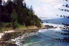
The Island's Formation More than two and a half million years ago the island that is now known as Norfolk was formed from the lava ejected by an undersea volcano. Physically the island is the highest point in a huge chain of mountains running 1100 miles from New Zealand to New Caledonia: the Norfolk Ridge. Eastward this vast submerged range is separated from the Australian continent by a plain 10,000 feet below sea level and a trench plunging more than 33,000 feet into the earth's crust. The island's highest point, Mount Bates, stands at 1,085 feet above sea level, but in actual fact is the tip of a mountain much larger than Mount Everest, the bulk of Mount Bates being submerged under the blue waters of the South Pacific. Erosion of the island's coast by the surrounding sea has reduced the island to about one-third its original size, and has formed the high cliffs that now make up much of its rugged coastline. Geological surveys have shown that the area surrounding Norfolk Island has all the earmarks indicating large natural gas and oil deposits. These as yet untapped resources, may, however, never contribute to the island, as Australia - 1,000 miles to the west - continues to lay claim to ownership of Norfolk Island's territorial waters and 200-mile economic zone. |
|||||